Thursday, September 6, 2012

Fall?

Since Hurricane Isaac blew through Louisiana and Mississippi last week and weekend, things have been downright gross here in Starkville. Thankfully, things are about to change, the question is will it be in time for the Auburn/Mississippi State football game, or will it make for a rainy game?

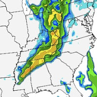
The different models have been agreeing that the front will come through sometime Saturday, with the latest run of the NAM, the rain and hot, moist air should be clearing by about 9am, setting up a for a great atmosphere for the football game.

The simulated radar on the NAM has the rain pushing through the area around dawn, nothing severe, but some strong storms possible.

6am Saturday
9am Saturday

Noon Saturday
The GFS also supports this rain moving through before noon, with very small accumulated rain amounts. This would be great news for the football game, making the wet weather a non-factor for the players, but also for the fans. 

This front is going take with it the heat and humidity, behind the front, dewpoints will be dropping from mid-70s on Friday into the low 50s on Sunday morning. Low temps will also respond Sunday morning,  into the mid 50s overnight Sunday, with a high Sunday near 80. This is welcome relief from the low-mid 90s we've had since Isaac came through. A taste of fall is on the way, and not a minute too soon. If the models are correct, the game against Auburn will be very pleasant. Cool(er) with a northwest breeze to put a lid on the hot temperatures.

After this weekend, the sun will stick around until late week, when there may be another cold front pushing towards the MS valley. Unfortunately with all that sun, things will be heating back into the 80s, even pushing 90 once again. Thankfully, the humidity will not be quite as oppressive as it has been this week.

Friday, August 24, 2012

Tropical Storm Isaac: No Big Deal?

After a very long siesta this summer, I have returned to the blogosphere. Good timing because if there is any weather to make people cranky, its a hurricane heading for the TX/LA/MS/AL/FL coast. I know, very specific in where it's heading.


This is the latest model data to Tropical Storm Isaac. I know, confusing, and clearly the models are not agreeing over where he is headed. I could go into how tropical cyclones form and move, but thats not all that interesting, and really you only want to know if you need to plan a vacation to Illinois or something next week. Well, if you take the average of the all these models, you are basically looking at what the National Hurricane Center's forecast is.


The NHC also predicts intensity, and currently, they believe he will be a Hurricane, but his strength is highly dependent on where he tracks over Hispaniola and Cuba, and how long he spends over them. His landfalls in Haiti and Cuba are also quite important to us in the U.S. because we can gather a lot more data from Isaac as he passes over land.

Personally, I think he is going to slide west some more, because he has consistently moved west the past couple days, wrecking forecasts that people have made. I am sorry that I cannot tell you how strong he will be, where he will/might make landfall, or when that occurs. I will say mid-late week in Mississippi/Alabama should be very interesting, and we should be cautious in making our plans.

One final note on TS Isaac, a couple models have him slamming into Jamaica first and then curve into Cuba, and then the U.S. This track would be very interesting, because Isaac would not travel over a lot of land to weaken him before coming into the Gulf.

You can stay up to date with Isaac via my twitter account, www.twitter.com/crankyweather, @crankyweather is the handle.

Tuesday, May 15, 2012

Beautiful Week and Weekend Ahead

Now that I am back home in East Tennessee, I hope to keep up the blogging. It was a wet Mother's Day here in at home, but beginning today and looking forward through the weekend, things are drying out, warming up, and making for a fantastic time to get outside and enjoy God's Creation.

The shortwave(s) that moved through the South over the weekend are finally pushing north east, and exiting the region, there is one small wave of energy that could bring us some convection later on Wednesday, but that is a very slight chance, otherwise, the atmosphere will continue to become more stable. The dew points will remain in the upper 50s to low 60s across much of the South, so things will be a little muggy, but it is May. Moisture should be on the rise here in the South at this time of year. Without the clouds and rain, and the sun shining on us, the temperatures will rise from the mid-60s this past weekend into the low-mid 80s by Saturday. Very pleasant and summer-like conditions are on their way to us. Even better than the summer though because I do not expect any pop-up showers or T-storms to develop in the afternoons.

The next real chance for any precipitation is looking to makes its appearance in our area on Tuesday according to the GFS, this would be the earliest I think it would arrive, and it will be another cutoff low associated with a shortwave off of an upper-level trough that will track over the weekend from California to Quebec, Canada.

Thursday, April 19, 2012

Washed Out Weekend?

I apologize for the very sporadic blogposts of late, life has been crazy. Thankfully the weather around Starkville is not quite so ridiculous. All of Starkville is looking forward to the weekend with Super Bulldog Weekend, but some in Starkville have events to attend to before that, Honors Orientation. The weather is going to make both events quite interesting.

Honors Orientation begins tonight at 5pm, and we can expect some nice conditions to kick off the event, winds will be light and southerly to southeasterly with temperatures right around 70 for the evening. Thankfully, a short wave is staying well to our north in Wisconsin for the duration of the evening. Unfortunately, as the high schoolers wake up and get ready for the full day of orientation, a cold front will be approaching, early in the morning it will be sitting to our north and west, draped from Illinois down through Missouri and Arkansas and back into Texas. Temperatures will most certainly be warm since we will still be in the warm sector on Friday afternoon, mid-upper 70s can be expected across the area just before the cold front arrives on Friday evening, just in time for the baseball game against Tennessee. Most of the rain appears to be lagging behind the cold front, and so rain may not reach the area until 9 or even after midnight. Behind this rain will be some cooler air, expect highs on Saturday to not even make it to 70, so if you are planning to go to the Spring Game and see Sugarland afterwards, be prepared for cool temps and a northwesterly wind which will continue to bring in the cool air. The rain looks to remain out of Northern Mississippi as a whole Saturday evening, so there is hope of not having a washout for the game and concert.

While there is weather threatening the events of this weekend, things are looking good for a successful weekend of events, from orientation, to baseball, to football, to a country music concert and the Starkville Arts Festival this weekend as well. Keep the rain jacket or umbrella handy this weekend, but things will not be a complete washout like Tuesday was of this week.

Wednesday, April 4, 2012

Easter Eggs or Fried Eggs?

I apologize for the long interval between blogs, things have been crazy here at Mississippi State. But we are back on track now! You may be wondering about the title to this post, well Easter egg makes sense since Easter is Sunday. However, I'm sure many of you are wondering about the fried egg part. Allow me to enlighten you.

As many you know, a common saying for how hot it is outside is "It's so hot you can fried eggs in the sunshine"or something along those same lines. Well, here at Mississippi State, things have heated up considerably and while it may not have gotten to fried egg status just yet, people are already worried about how hot the summer will be. Let me put some of those fears to rest, current forecasts are for the temperatures this summer to be about average for Mississippi, as well as precipitation. Furthermore, we are looking at a possible cool down this weekend as we head into Easter. Some predictions even have 40s for lows Monday morning!

Mississippi and the Deep South as a whole have been under some sticky weather as of late; hot, humid and sunny skies have established themselves over the region. The storms that went through the Dallas-Fort Worth area yesterday are a part of a low pressure system that is slowly making its way across the Plains and headed for the South. With it, we can anticipate drier and cooler air to slide in behind it. Current models are indicating the system and its associated cold front to come through sometime on Friday. This will give us here in Mississippi relief from the threat of storms every afternoon and evening, which we have dealt with since Monday afternoon.

Easter is looking like a great time to get out with family and friends, search for some Easter eggs, and to remember why we celebrate Easter, because Christ has risen!

Thursday, March 22, 2012

Spring has Sprung

Across much of the eastern half of the country things have warmed up considerably since we last spoke, and these warm temperatures have spread across the rest of the nation except the northwest corner of the US.
This huge warm up last week left many in the South sneezing as the trees are now pollenating. This is the current map of pollen counts across the country.

Mississippi is lower only because over the past 48 hours over 5 inches of rain has fallen in some areas of Mississippi. This rain is slowly clearing out of Mississippi and the front itself should be making its way through tomorrow during the day. The front is still stalled out over east Texas. The whole system will very slowly lift out of Texas, move through Arkansas and into Tennessee and Kentucky.  I anticipate the low to have an influence on us here in Mississippi til Sunday evening, when it finally reaches South Carolina. Things will begin to clear out on Saturday and hopefully dry out as well. Temperatures will bounce back into the 70s on Saturday. I doubt we will hit 80 until Tuesday or Wednesday and by then, there looks to be another system that will be affecting our weather here in Mississippi. I hope this general look at the weather from earlier this week and a peek into next week was insightful and helpful!

Wednesday, March 7, 2012

Spring Break Mode: Colorado

Only two days til spring break begins, and I am so ready for it to be here! In honor of my departure for a week to Fort Collins, Colorado for spring break.

The one to the right is GFS surface temps for Friday at noon, about when we are departing. The one below is the NAM version of the same thing. Using the chart, it can be determined that some colder air is going to be in place of Tennessee, Mississippi, Arkansas and Oklahoma; however the GFS is more progressive in bringing back the warmer temperatures. So for the drive, the cold front will be south or east of our route, and it will be well above freezing for us during the day, and so driving conditions should be good for the trip across the Great Plains.


Once we get there, things are looking fairly nice for Northern Colorado in early-mid March. There will be a low developing the lee of the Rockies on Sunday-Tuesday in Southeast Colorado. This low will remain east and/or south of Fort Collins, keeping myself and our group in an area of NVA(DIV) sinking air. Clear skies are anticipated through Tuesday night. Clouds appear to be pushing into the area Wednesday morning into afternoon. These clouds will be fleeting and Northern Colorado is going to continue to have wonderful weather through the entire week. The closest threat of poor weather looks to develop off the California coast with a deep trough on Thursday. Thankfully this system will not make it to Colorado until Friday at the earliest, by which point we will all be on the road, or even back home in Starkville. Due to the sunny skies, I anticipate slightly warmer highs than usual, but the lows to remain average.

Saturday: Sunny, 54 F.
Sunday: Sunny, 63 F.
Monday: Sunny, 67 F.
Tuesday: Sunny, 65 F.
Wednesday: Partly Cloudy, 64 F.
Thursday: Mostly Cloudy, 59 F.

Tuesday, February 28, 2012

Spring Break Is Coming!

In honor of the fact that Spring Break is just a week and a half away here at State, and the fact that my sister's Spring Break is next week, I figured I would give her fair warning about the weather for next week! Please note, this is a forecast for 5-10 days in advance, this is all subject to change as this is not the easiest thing to forecast. As one of my professor says, "Anything past 3 days is magic."

Ocean City, Maryland:
Ocean City is right on the ocean(duh!), here is a Google Earth image to show you all where exactly it is. It's right along the border of Maryland and Delaware on the Peninsula.

The weekend to start spring break(this coming weekend) is not looking so great for anyone on the East Coast. GFS is the free model that goes out past 3 days into the future, and currently it is showing a large low pressure in Ontario on Saturday morning, with a long cold front extending through much of the Mid-Atlantic, and even into the Deep South. Most of what Ocean City can expect is rain, since temperatures will be above freezing through Saturday night into Sunday morning. I doubt temps will recover much on Sunday as the cold front moves through Saturday night into Sunday. Highs should hang out in low-mid 40s for Sunday. Sunday night might reach down to freezing with the clouds having cleared out during the day on Sunday. A slow warm up will occur from Monday into Tuesday. Monday should be in the upper 40s, Tuesday will be in the low-mid 50s with southeasterly winds. Unfortunately, this is in advance of another system that by Tuesday afternoon/evening will be approaching. Wednesday morning is currently when I anticipate this making an impact on Maryland. Thankfully it should push quickly out of the area and by Thursday things will clear out again and warm up once more. The GFS expects a very quick warm up into the high 50s and pushing sixty. This warm up is again very short-lived with another system taking direct aim at VA/MD/DE for Thursday evening. Unfortunately, outdoor activities may be rather limited due to the weather for my sister and her friends. Thankfully all of this will not be snow or any other wintry precipitation.

Saturday: Rainy.
Sunday: Clearing, cool. 44 F.
Monday: Sunny 48 F.
Tuesday: Sunny, warmer 54 F.
Wednesday: Cloudy with rain moving in later: 52 F.
Thursday: Rainy and warm 58 F.
Friday: Cooler, 49 F.

Next Week I will plan on discussing Fort Collins, Colorado, since I will be headed there for my spring break! Hope you enjoy this!

Saturday, February 18, 2012

Progressive Pattern Over The South

It has been awhile since I have written much about Oak Ridge and the rest of East Tennessee. However, today is as good a day as any to get back on the horse.

Things are shaping up to be something very interesting in terms of snowy/sleet/rain mixtures. Current models and forecasts are for the accumulating snow to be up to the north, closer to the TN/KY border than in Oak Ridge.

As I write this post, national RADAR shows the rain is pushing into the area from the south and west. However, it appears to be in the form of virga. Virga is when the rain evaporates in the air between the cloud it fell from, and the ground. The rain is associated with a low that is currently still sitting over Central Texas. This low pressure is not very strong. This image shows the vorticity(uplift) surrounding the low, the uplift is what is causing the clouds, and the precipitation. Much of the precipitation at the moment is in Louisiana and Southern Mississippi and Alabama.

The brighter colors indicate positive vorticity. The numbers are pressure heights

This is the GFS map of the same thing.
The GFS shows just how weak this system is. The GFS is has the low as very disorganized. The GFS is also brings the low and the cold front to the south of East Tennessee, meaning we will have winds shift from out of the east, to the north and then to the northwest.


This low is going to make its way towards Tennessee, and the precipitation will move into the area overnight and into tomorrow. Along with the low, there is a cold front which will pass just to the south of East Tennessee on Sunday morning. While the cold front is to our south, temperatures will not get very high Sunday. The high will be sometime during church, and as you make your way to lunch, the wind will be shifting from the NE, to out of the NNW. The temperatures will drop from then on. Highs around East Tennessee should only make it into the mid-40s.

Once this system clears out Sunday night, temperatures will drop into the mid-upper 20s. Sunday night is when there may be some snowflakes, and in SE KY there will be some accumulation, but not much.
The mountains should also get some snow due to the altitude. Monday and Tuesday show a slight warming trend, with lows in the mid-upper 30s, and highs getting back to near 60 on Tuesday before another system looks to make an appearance Wednesday into Thursday. None of these systems are very strong, nor are they bringing with them lots of cold air because they are coming up to us out of the deep Southwest. We are under a progressive pattern with systems steaming across the country every few days, keeping us wet, but not really cold. Things do not seem to be changing until next weekend or early next week. Then we MAY finally get out of this pattern, and get a low from the Northwest instead of the Southwest. If this is the case, March may very well come in like a lion! Gotta love old wives' tales!

Monday, February 13, 2012

HAIL STATE

Dear Readers of crankyweather,

I certainly hope that as you have read this blog that you understand at least a little of what I say. However, apparently not everyone at Mississippi State University is quite as literate in weather as you wonderful people are. Today, as we had some snowflakes, sleet and rain come down on campus, the students were all talking about the "hail" outside. Twitter was full of students commenting on how ironic it was that it was hailing at state, where a common greeting is "Hail State." I am writing this today to put down this bit of unintelligent thinking, and to  combat the rumor that in the winter, it can hail whenever, as opposed to in the summer, when hails comes down only in certain thunderstorms. According to dictionary.com, sleet is defined as "precipitation in the form of ice pellets created by the freezing of rain as it falls." Hail on the other hand is defined as "showery precipitation in the form of irregular pellets or balls of ice more than 1 / 5  in. (5 mm) in diameter, falling from a cumulonimbus cloud." I would like to go further than just this general definition, which, in all honesty is a little wordy and confusing.

Hail is created during a thunderstorm by the updrafts and downdrafts of the storm. A raindrop begins its life as a piece of ice; at the altitude at which they are created, it is below freezing. When this raindrop falls in a thunderstorm, it falls, melts and combines with other raindrops, but before it falls out from the cloud, an updraft picks it up and sends it back up to the top of the storm, where it refreezes. So this same raindrop, just larger, has frozen, and begins falling to earth again. This process happens several times, and eventually the hailstone will be too heavy for the updraft to send back up, and so it falls to earth. This is the life of a hail stone. Sleet has a much simpler life story.

Sleet, begins as a snowflake! Thats is awesome just by itself, I know. Anyway, the snowflake begins falling to earth, but as it falls, it reaches air that is warmer than freezing. This snowflake melts there, however below this layer of warm air in the sky, there is another layer of cold layer. This layer refreezes the snowflake, only now its not a snowflake, but an ice pellet... sleet. The sleet then falls the rest of the way frozen to the surface where it hits you in the head, and you notice it more so than rain or snow, because it hurts more. This is why sleet, snow and rain can all occur simultaneously. Because each individual flake, pellet or drop is going through this on its own and may not be at the same stage. 

Freezing rain is another winter precipitation type people are often confused on. Freezing rain happens when the ground is below freezing, but the air directly above it is not. This means the sleet doesn't refreeze until it hits the ground. This creates a glaze over the surface, on roads, this is known as black ice. This type of ice is quite common in North Carolina, which is infamous for its ice storms. Freezing rain is extremely dangerous because it is hard to see, especially at night. If anything is "shiny" and you are driving on it, take extreme caution, or better yet, stay home, read a book, sit by the fire and have something warm to drink!

In conclusion, sleet does NOT equal hail. Sleet is often mixed with snow and rain. Hail happens during a thunderstorm. Hopefully this has cleared up some questions that may have been in your mind as you went about your business today. :)
Monday, February 6, 2012

Campus Connect Forecast

My Campus Connect forecast for Practicum lab this week.


We covered teasing weather, which is where we have a 20-40 spot where we invite people to come back after the commercial break to find out what the weather story is for the day.


This is the full forecast for this week. Enjoy! Critique is also very much welcomed.

Saturday, February 4, 2012

Weather: In Pictures

Taking a quick break from forecasting here tonight, and sharing some of my pictures from Christmas break.


Over Christmas, John King, my roommate and I went up to the Smoky Mountains to visit, it was his first time, and considering I live an hour and a half away, it was the perfect reason to go. We went to Abrams Falls, since I hadn't been there and its only a two mile hike to the falls. This is what greeted us when we came down a hill and around a corner. Of course, we took pictures with the falls, cuz thats just what geoscience majors do.


We began hiking back, and found some evidence of the April tornado outbreak, Tuscaloosa wasn't the only place that got hit, even the Smoky Mountains were affected by them. This dispels a common myth about tornados, they are not affected by hilly or uneven terrain. Living in the mountains does not completely protect you from tornados.
You can kinda see how the trees fell.

This shows it better, how a good sized swath of trees were blown over and twisted.

If you look past the foreground, which isn't very interesting, you can see a large section of trees destroyed by the tornado.

Just a nice picture of the creek/river along the trail.
This trail was closed for several months due the tornados, where the trees and other debris were blocking the trail in several places. Thankfully, it reopened mid-summer, and so by December when John and I hiked, the trail was cleared. They did have to burn along some sections of the trail to remove the debris from the tornados.

Well, I hope you enjoy this little slice of my life, with a little tornado thrown in. I thought this would be nice since it has been a super warm here in Mississippi this winter, and when its a warm winter, you can expect dangerous storms, and tornados can occur.

Saturday, January 28, 2012

Warm week in Stillwater!

Welcome back folks!

This has been a warm winter across the eastern half to 2/3 of the United States, and it's no different in Stillwater. Things have cleared out since the low pressure system moved through on Wednesday, and this is going to allow nightly temperatures to drop, however with clear skies, temps will rebound each morning over the next week, until another system makes its entrance onto the Plains.

Due to a zonal pattern setting up over the country, the forecast over this next week is going to be fairly constant. Temps will drop into the mid to low 30s tonight with clear skies, but the temps will return to above 50 on Sunday afternoon. Sunday night things will only drop into the lower 40s, which sets a nice warming pattern for the work week. Monday night there looks to be a small system to the north of the area moving through, so some clouds, and a little rain will push through the area through the morning on Tuesday, but shouldn't affect Wednesday much at all. This system will not effect temperatures either, and the warming trend will continue on Wednesday. Stillwater should be around 60 through Thursday. Friday is when things will be changing. Next weekend currently looks to quite cold. Could this be the winter we've been waiting on? We shall just have to wait and see. February may bring the wintry scenes we have either dreaded or dreamed about.

Saturday night: Clear 36 F.
Sunday: Sunny 57 F.
Sunday night: Not as cold, 41 F.
Monday: Warm and Sunny, 61 F.
Monday night: Clouds, 40 % of rain, 48 F.
Tuesday: Rains and Clouds, 60 F.
Tuesday night: Clearing, 43 F.
Wednesday: Sun Returns,  58 F.
Wednesday night:  Clear, 42 F.
Thursday: Warm, 60 F.

Hope you enjoy this bit of forecasting, I would love to get some feedback, so please comment!

Monday, January 23, 2012

Oak Ridge, TN Wx

Last night was a crazy night in weather, however things across the Southeast are a little calmer today. Welcome back!

Oak Ridge is in East Tennessee between the Smoky Mountains and the Cumberland Plateau. It is home to a national lab, and is where part of the Manhattan Project was located(ya know, atomic bomb). Anyway, the nearby university is the University of Tennessee at Knoxville, the Volunteers.

An unsettled pattern seems to be developing for the Southeast, this system that came through this morning in Oak Ridge, produced a lot of severe weather to the west and south. Especially in Arkansas and Alabama. There appears to be a low that will be cutoff in the south west, if it hasn't already, that will slowly make its way towards the Southeast Wednesday through Friday. Models show this low system will track south of us, through Louisiana and Mississippi to the Gulf and then up through Georgia and South Carolina. However, there appears to be an Alberta Clipper to our north that will move through Illinois, Indiana and Ohio at almost the same time. This puts East Tennessee between a rock and a hard place. To our north, they may very well receive snow, and to our south should just be really wet. I believe that between these two, we will get some solid rainy day, but no real change in the temperatures as we will be along the warm front of the southern system. This will keep our temperatures in check, so no snow :( Another system looks to be heading our direction on Sunday as well, so a pattern of clear for a day or two, then a system should begin to set up. This could eventually bring us some colder temperatures, something all snow enthusiasts haven't missed this winter across the South.

Monday night: Some clouds, 36 F.
Tuesday: Mostly Sunny, 52 F.
Tuesday night: Partly Clear, 33 F.
Wednesday: Clouds build in throughout day, and the temps increase through day into night. Chance of showers 40% more in the evening, high will be closer to midnight than noon, 54 F.
Thursday: Rainy, 58 F.
Thursday night:  Rain hanging around, 70%. 43 F.
Friday: Rain will slowly clear out, slightly cooler, 54 F.
Friday night: Mostly Cloudy, cooler. 34 F.
Saturday: Partly Sunny, cool. 48 F.
Saturday night: Clouds moving back in, 31 F.
Sunday: Cloudy, 30% chance of rain. 44 F.

Friday, January 20, 2012

Well Starkville and Mississippi State, here is your weather!

Tuesday, January 17, 2012

Bloomington-Normal, Il Wx

Welcome back! This still feels odd blogging, but here we go!

Some background to Bloomington-Normal, Il, it is actually two college towns that have grown into each other, Bloomington is the southern city and is home to Illinois Wesleyan University, the Titans. Normal is to the north and east, and is home to Illinois State University, the Redbirds. Also, Bloomington is the headquarters for State Farm Insurance. In terms of weather, Bloomington is in Central Illinois, and in the praires of America. Flat, and windy would be a fairly accurate description. Green energy has developed in the area due to this, with wind farms sprouting up on the northwest side.

Things have cooled down to very wintry temperatures. As an upper level trough moves through late Tuesday evening into Tuesday night, the winds will pick up out of the northwest to around 15-20 mph, with gusts that could reach 30 mph. The winds I believe will prevent temperatures from dropping too drastically, but expect the low to be in the mid-teens. Things are not going to be warming very this week at all. There is another small system looking to come through Wednesday night into Thursday, and another from Friday into Saturday. This rapid fire of systems is not allowing temperatures to warm up, and while sunny for Wednesday, I do not expect temperature to get much above freezing, if at all; so bundle up for tomorrow. Clouds and a little snow will be coming in late Wednesday and into Thursday, so anticipate some snow showers, but I doubt there will be much in terms of accumulation. If there is any accumulation, look for it to be north of Bloomington, and possibly even north of Pontiac. Thursday is going to be very cold as well, as the front passes late morning, early afternoon. The high could easily be Thursday morning, and the temps drop off the rest of the day. The national weather service sees the system on Friday as one with a better potential for snow accumulation. Friday's snow should not arrive until later Friday evening and into Saturday morning. I do not think there will be much upper support for the cold air. All in all, its gonna be a cold and wintry few days ahead in Bloomington, my advice? Find a fireplace, an animal to cuddle with, hot chocolate, and a good book.

Tuesday night: Cold. 16 F.
Wednesday: Mostly Clear, 31 F.
Wednesday night: Cloudy, 21 F.
Thursday: high in the AM, cloudy. 30% snow showers. Little to no accumulation. 23 F.
Thursday night: Frigid, 11 F.
Friday: Sunny,  Cold 24 F.
Friday night: Cold with 40% snow showers, 20 F.
Satruday: Lingering snow showers, 30%. Still cold. 29 F.

Monday, January 16, 2012

Stillwater, OK Wx

Hey guys!
Well, this is my first weather discussion, and I'm not sure about what I'm doing, but here we go!

A little bit of background about the area. Stillwater is in the north central part of Oklahoma, and is home to Oklahoma State University, The Cowboys! This university and town are quite similar to Mississippi State University and Starkville.

Lately, central Oklahoma has been under short waves of cold, Arctic air from Alaska, another one of these waves is coming through tonight. With the upper-level activities tonight, there is a chance for some showers. Temperatures Tuesday are going to be chilly. Tuesday night  could dip into the teens for central Oklahoma. Luckily for the cold-blooded, a quick warmup is on its way, and by Friday, temperatures will be well into the 50s, possibly upper 50s.

Monday night: Cloudy, 20% showers. 34 F.
Tuesday: Sunny, 41 F.
Tuesday night: COLD and clear, 19 F.
Wednesday: Warmer, mostly sunny. 49 F.
Wednesday night: Clear, 30 F.
Thursday: Partly sunny, 54 F.
Thursday night: Mostly Cloudy, 38 F.
Friday: Mostly Clear, 56 F.

Saturday, January 14, 2012

Crankyweather is officially up and running! My hope for you as a reader is to get information that is useful to you, as well as interesting! Currently my plan to write about weather in certain places around the country, mostly places that I am fond of. Oak Ridge, Tennessee, Starkville, Mississippi, Bloomington-Normal, Illinois, and Stillwater, Oklahoma! You can also follow me on Twitter for quick updates! www.twittercom/crankyweather